Two terms that we come into contact with as makers of maps. It is not unusual if these two terms sound at all strange to you. It's not, and we'll clarify through this blogpost. So, where to start? What is the difference between these two, and what does it mean? Let's start with the most known of the two.
Grid
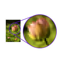
Any photo or image as you know it, from any webpage is almost always made up of pixels. Pixels we know are the blocks that we see when we zoom in on a photo. As you zoom in more, more blocks appear, or pixels. A raster file is characterized by the use of pixels.


Pros and cons
Grid maps and vector maps both have separate properties. Some more useful and accessible than the other. The thing that makes a grid layout so strong and accessible, for example, is the following. Raster is the leader in the field of file formats in terms of photos, images, maps, icons. Everything that is graphically visible really. All computers, telephones, digital boards and other carriers of media can handle this type. If you would print a photo or the like, then you can also see on the print that loose dots are visible. Seems almost too good to be true doesn't it? It is not for nothing the most commonly used format. Yet there is one aspect where gridmaps loses out to vector maps, and that is quality.
Vector maps
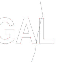
To be blunt, where vector will always win over raster is the preservation of quality. It can not be stretched, twisted or inflated without losing any quality. Vector maps are made up of points, lines and surfaces. This type of structure contrasts with the pixels of the raster layout. However, the number of images, illustrations and photographs that are taken made from vector, are vastly limited. There is an area where they flourish the most. Don't look now but; maps and also atlases, there it reigns supreme!


Vector outline
It is therefore essential for us to be able to work with vectors in order to preserve the quality of our material. Vector is flexible and can easily be transformed into other forms. Something grid has a very difficult time with. This way, even loose data can be placed on a piece of vector file. This is where the possibilities really become interesting. If we want to dive deeper into this we will do that in a next blog post. For now, hopefully you have become a bit wiser about the use and the advantages and disadvantages of raster maps and vector maps.

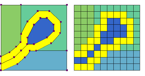
Vector Grid difference
Our raster and vector maps can be found on this part of the website. If you feel like experimenting with raster and vector maps, you can download them here for free.
Do you have any questions, or are you missing something? Let us know!