- Delivered as EPS & JPG
- High-quality downloads
- Over 30 years of experience
✅ Diverse formaten
✅ Niet goed, geld terug
✅ Meer dan 30 jaar ervaring

Earlier this year, the complete postal code map of Europe was released. What sets this Europe-wide postal map apart from earlier editions is its underlying map projection. This projection makes it possible to adjust the map consistently across all regions while preserving geographic accuracy.
In its standard form, the map already includes roads and populated places, ensuring a usable level of detail from the outset. Depending on the intended application, additional places, road networks or other geographic information can be integrated. Because the map is built as a digital vector map, its structure allows for controlled adjustments while maintaining visual balance and clarity across the entire European area.

The map shows postal code areas, names and boundaries for all European countries. In most cases, these postal regions are represented at a two-digit level, while smaller countries are shown using a single-digit structure to maintain clarity.
A notable inclusion is Ireland, whose postal code areas are now fully integrated into the map. Until relatively recently, Ireland did not use a national postcode system, making its presence a significant update within the European postal landscape. This addition contributes to a more complete and up-to-date overview of postal regions across Europe.
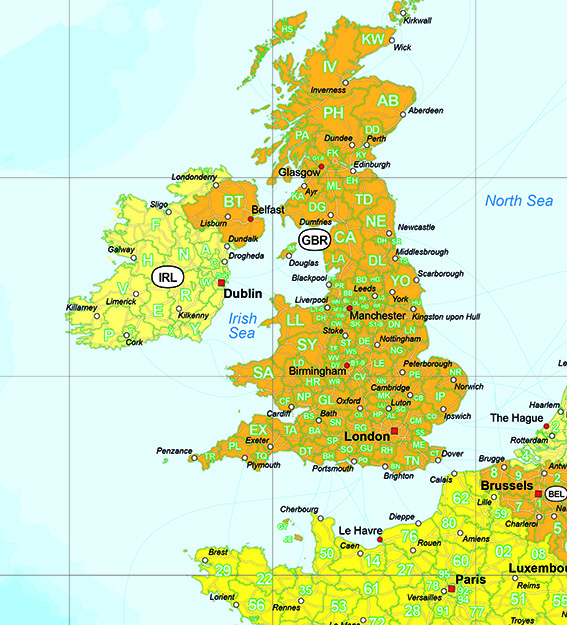
All Eastern European countries included on the map are covered by clearly defined postal code areas. This ensures a consistent and complete representation of postal regions across both Western and Eastern Europe.
Because the map is built on a flexible cartographic structure, it supports a wide range of applications and layouts without compromising geographic accuracy. Its design allows the postal data to remain clear and readable across the entire region, even in areas with complex boundaries or densely structured postal zones.